Canada, New Brunswick and Nova Scotia
Image
Canada, New Brunswick and Nova Scotia
Content type |
Content type
|
||||
---|---|---|---|---|---|
Collection(s) |
Collection(s)
|
||||
Title |
Title
|
||||
Resource Type |
Resource Type
|
||||
Description |
Description
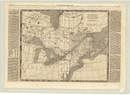
Map depicts Eastern Canada, around the St. Lawrence River and the Great Lakes. Includes New Brunswick and Nova Scotia. Map is in The Illustrated London News under the heading "Visit of the Prince of Wales to North America." Pages 258 and 258, Sept. 15, 1860. There is text in two columns on the right and left side of the map which described the area. Map is the recto side of a double-sided document.
|
||||
Extent |
Extent
1 map ; 36 x 41 cm on sheet 40 x 57 cm
|
||||
Note |
Note
|
Content type |
Content type
|
||||||||
---|---|---|---|---|---|---|---|---|---|
Collection(s) | |||||||||
Title |
Title
|
||||||||
Resource Type |
Resource Type
|
||||||||
OCLC Number |
OCLC Number
606372865
|
||||||||
Organizations |
Organizations
Publisher (pbl): The Illustrated London News
|
||||||||
Geographic Subject |
Geographic Subject
|
||||||||
Hierarchical Geographic Subject |
Hierarchical Geographic Subject
North America
Canada
Eastern Canada
|
||||||||
Origin Information |
Origin Information
|
||||||||
Note |
Note
|
||||||||
Physical Location |
Physical Location
W.D. Jordan Rare Books and Special Collections, Queen's University Library
|
||||||||
Shelf Locator |
Shelf Locator
R252
|
||||||||
Rights Statement |
Rights Statement
|
||||||||
Language |
Language
|
Language |
English
|
---|---|
Authored by | |
Name |
Canada, New Brunswick and Nova Scotia
|
Authored on |
|
MIME type |
image/tiff
|
Width |
14409px
|
Height |
10524px
|
Media Use |